Ancient Rome Geography
- Geography of Ancient Rome
- Geography of Roman Gaul
- City Plan of Rome
- The Tiber
- Provinces of Rome
- Cities of Rome
- Herculaneum
- Pompeii
- Lepcis Magna - Lepcis Magna is one of the best preserved and most significant Roman cities in Africa.
- Roman Roads
- Seven Hills of Rome
- Maps of the Roman Empire
- Roman
Place names
The Tiber flows through Rome and rises on the slope of Monte Fumaiolo, entering the Tyrrherian Sea. Originally known as the Albula, it was renamed Tiberis because of the King Tiberinus who drowned in it. The river is 405 kilometers long, 20 meters deep at its deepest and 120 meters wide at its widest.
 Pompeii
Pompeii, was built at the mouth of the Sarnus River, a few miles south of Mount Vesuvius, between Herculaneum and Stabiae. Under the dictator Lucius Cornelius Sulla it became a Roman colony in 80 BC and later it was a favorite resort for wealthy Romans, reaching a population of about 20,000 at the beginning of the Christian era. Pompeii disappeared after the eruption of Mount Vesuvius in 79 AD.
- Eruption of Vesuvius
- City of Pompeii
- The Pompeii Forum Project - The Pompeii Forum Project is a collaborative venture that focuses on the urban center of Pompeii.
- Pictures of Pompeii
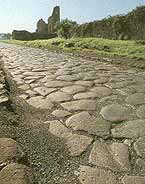 Roman
Roads - It is often said that "all roads
lead to Rome," and in fact, they once did. The road system of the Ancient
Romans was one of the greatest engineering accomplishments of its time,
with over 50,000 miles of paved road radiating from the center of Rome.
Although the Roman road system was originally built to facilitate the movement
of troops throughout the empire, it was inevitably used for other purposes
by civilians then and now.
Roman
Roads - It is often said that "all roads
lead to Rome," and in fact, they once did. The road system of the Ancient
Romans was one of the greatest engineering accomplishments of its time,
with over 50,000 miles of paved road radiating from the center of Rome.
Although the Roman road system was originally built to facilitate the movement
of troops throughout the empire, it was inevitably used for other purposes
by civilians then and now.- How to built a roman road
- The Construction & Makeup of Ancient Roman Roads - by Adam Pawluk
- Roman Roads in Britain
- The Appian Way -
The Appian way is the oldest and most famous road built by the ancient
Romans. It was built in 312 BC by the Roman censor Appius Claudius Caecus.
The road went south from the Servian Wall in Rome to Capua. It passed
through Appii Forum and Terracina, and later on was extnede so that
it reached Brundisium, now called Brindisi. The main route to Greece,
the Appian Way was more than 560 km (more than 350 mi) long. The road
was well constucted, although the present pavement of large hexagonal
block made from lave, laid on a firm foundation and strengthened by
cement, is probable not the original bed. From Rome to Terracina the
course is nearly straight, despite the steep slopes of the Alban Hills
and the swamps of the Pontine Marshes. Near Rome the road was lined
with tombs, of which the ruins of many can still be seen. Parts of the
road are still in use. The road is also famous because after the revolt
of Spartacus and the other slaves, they were all crucified along this
road.
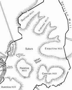
Capitoline Hill - The Capitoline is the smallest, but best known of the seven hills of ancient Rome. The hill was dedicated to Jupiter, Juno, and Minerva, and was the historic and religious center of the city. The temple of Jupiter was located on the south west end, the temple of Juno on the height known as the Arx. Between these is an area called the Asylum. It is said that this is where Romulus, the founder of Rome took in refugees from nearby towns. During the construction of the temples, a human skull was unearthed. Taken to be an omen, the Romans believed this meant their city was to be the "head of the world". Palatine Hill - Cicero and Catullus both lived on the Palatine. Augustus was born and lived there as well. The best preserved buildings are the House of Augustus and the House of Livia. Several other emperors also built palaces on the hill. Aventine - A mostly residential hill. The Circus Maximus stands between the Aventine and the Palatine. Said to be one of the most peaceful areas in Rome.
Esquiline - Largest of the seven hills. The baths of Titus and Trajan were located here, as well as the Golden House of Nero.
Quirinal - Used to be the most residential of the seven hills. On the east end of the hill were the baths of Diocletian.
Viminal - A smaller ridge between the Quirinal and Esquiline.
Caelian - Southernmost of the four large hills.
- Map of the Roman Empire
- Maps of the Roman World in the First Century
- The Roman Empire in 1st - 3rd century AD
- Rome at the time of Trajan
- Maps of Ancient Warfare - From the Department of History at the United States Military Academy
- The Second Punic War
- Trading Products in the Roman Empire
- Trading Routes